Long trips ask the driver to plan, pace, and drive at once. PathPal handles the first two.
PathPal is an in-vehicle trip planning and driver assistance platform designed to make long-distance road trips safer, less stressful, and more enjoyable. The concept helps drivers manage fatigue, coordinate group travel, and automate trip planning through intelligent route recommendations and proactive driving assistance.
Problem
Drivers plan the route, track their own fatigue, and coordinate every stop while driving. Navigation apps optimize directions and stop there.
Solution
PathPal plans the trip, prompts breaks before fatigue sets in, and lets passengers add stops, so the driver is left with the driving.

Customer Experience Designer
FigmaJan 2026 - May 2026In-Vehicle & Mobile
five courses, one trip
Let’s Break My Process Down
Research
The project explored the challenges drivers face during long-distance travel and identified opportunities to reduce stress while improving safety and trip coordination. We evaluated existing navigation platforms and mapped the end-to-end travel experience to uncover unmet user needs.
Competitor Analysis
To evaluate existing navigation platforms and uncover unmet user needs.
We looked at three tools drivers already reach for: Waze and Google Maps for live navigation, Roadtrippers for planning a route worth taking, and A Better Route Planner for keeping an EV charged. Each is strong in its own lane, and none of them covers the whole trip.
| Features / Criteria | Waze & Google Maps | Roadtrippers | ABRP |
|---|---|---|---|
| Real-Time Navigation | Waze & Google MapsYes: Live ETAs and traffic rerouting | RoadtrippersNo: Not the focus | ABRPPartly: Routing built around charging |
| Stops Along The Way | Waze & Google MapsYes: Gas, food, and EV chargers | RoadtrippersYes: Attractions and suggested places | ABRPPartly: Charging stops only |
| Trip Planning & Itineraries | Waze & Google MapsNo: Built around one destination at a time | RoadtrippersYes: Multi-stop routes with budgeting | ABRPPartly: Charge-optimized plans only |
| Collaborative Travel | Waze & Google MapsPartly: Shared locations and lists | RoadtrippersNo: Not identified | ABRPNo: Not identified |
| Energy & Range Awareness | Waze & Google MapsPartly: Charger locations only | RoadtrippersNo: Not identified | ABRPYes: Predicts energy use and routing |
| Fatigue & Break Support | Waze & Google MapsNo: Not identified | RoadtrippersNo: Not identified | ABRPNo: Not identified |
| Overall Opportunity | Waze & Google MapsStrong on the drive, thin on planning it | RoadtrippersStrong on planning, absent once the trip starts | ABRPStrong for EV range, narrow everywhere else |
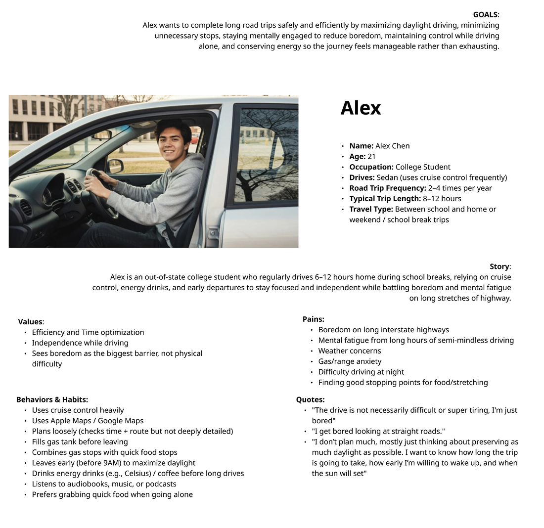
User Persona
To represent the long-distance driver the platform is designed for.
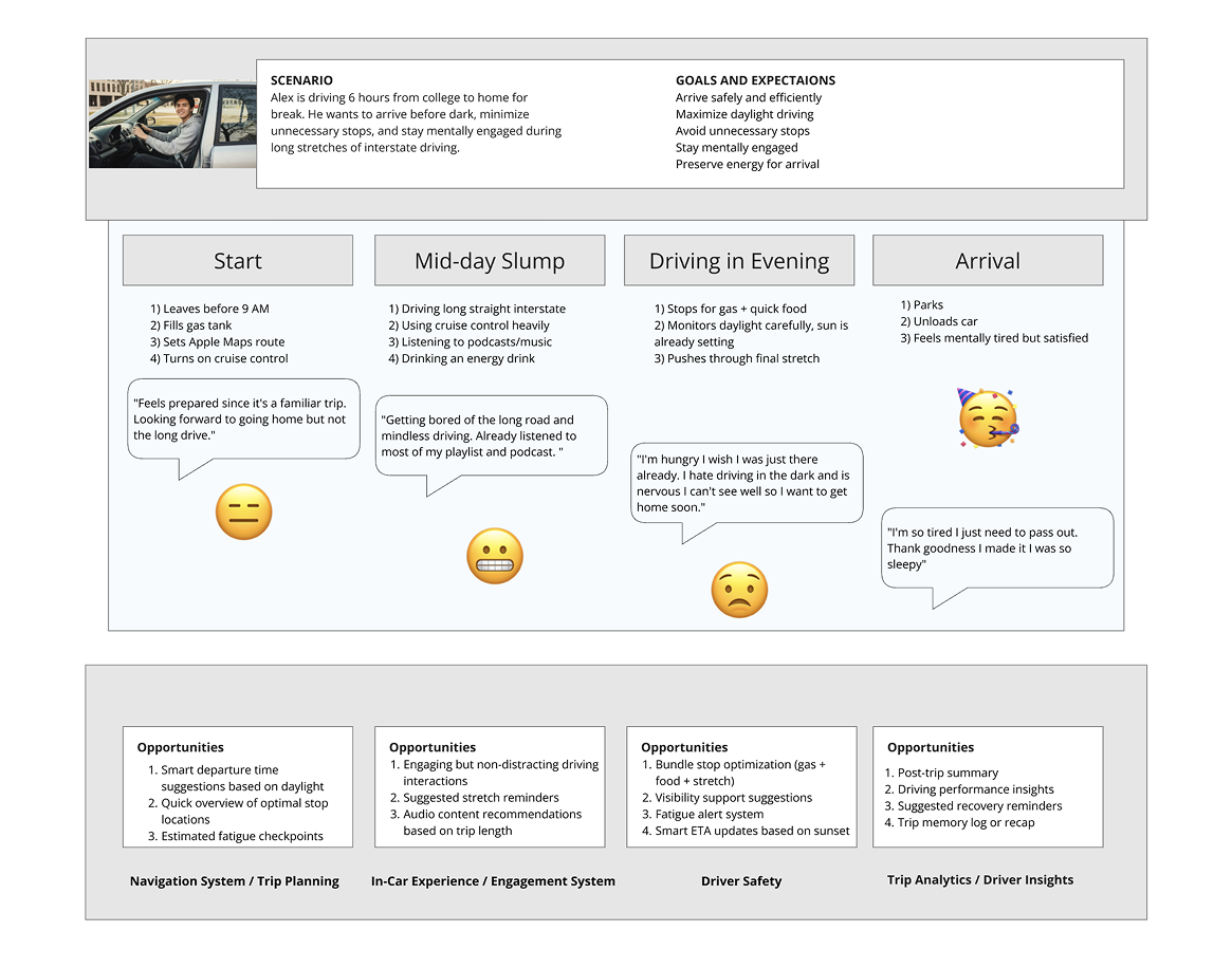
Journey Mapping
To map the end-to-end travel experience and find where drivers lose time, focus, and confidence.
Key Insights
Three insights defined where existing navigation tools left drivers unsupported.
Driver Workload
Drivers often shoulder the responsibility of navigation, planning stops, and monitoring travel conditions, creating unnecessary cognitive load during long trips.
Fatigue & Safety
Users lacked timely reminders and guidance for managing fatigue, making it difficult to recognize when breaks were needed.
Trip Coordination
Existing navigation apps offered strong routing capabilities but limited support for collaborative travel planning, shared decision-making, and group coordination.
Design
The design focused on creating a driving companion that proactively supports users throughout every stage of a road trip, from planning to arrival.
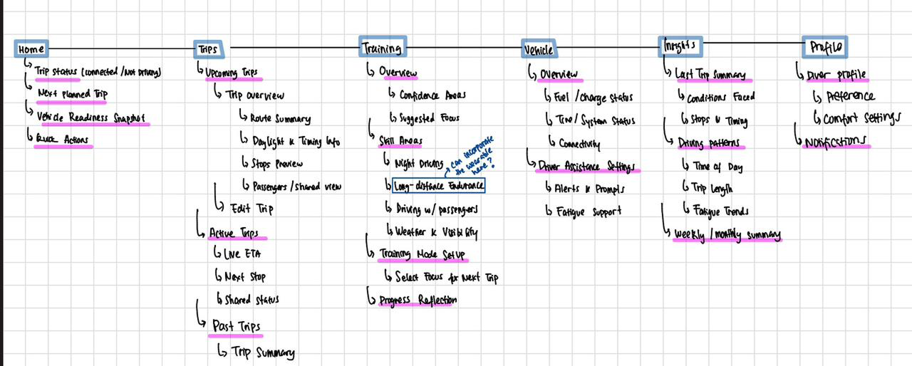
Information Architecture
Mapped user flows around trip planning, route management, navigation, and safety alerts to create an intuitive driving experience.
Wireframing
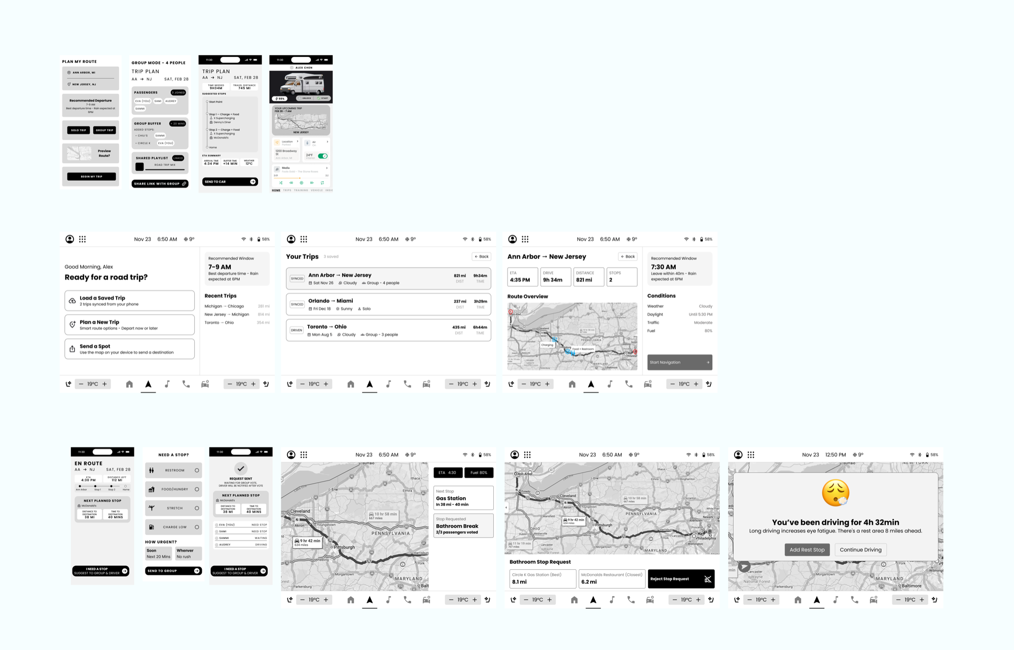
Explored layouts for trip planning, route summaries, navigation, fatigue notifications, and collaborative travel features.
High-Fidelity Prototype
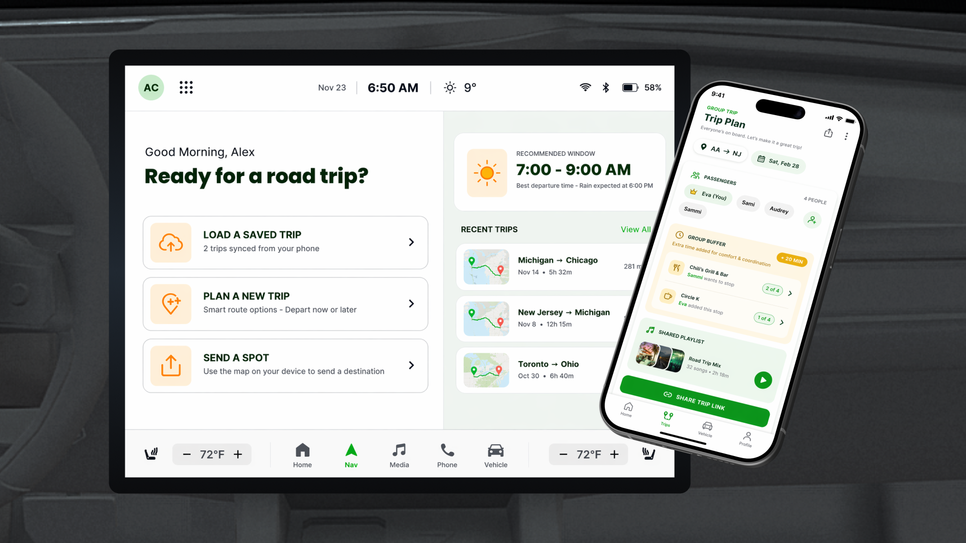
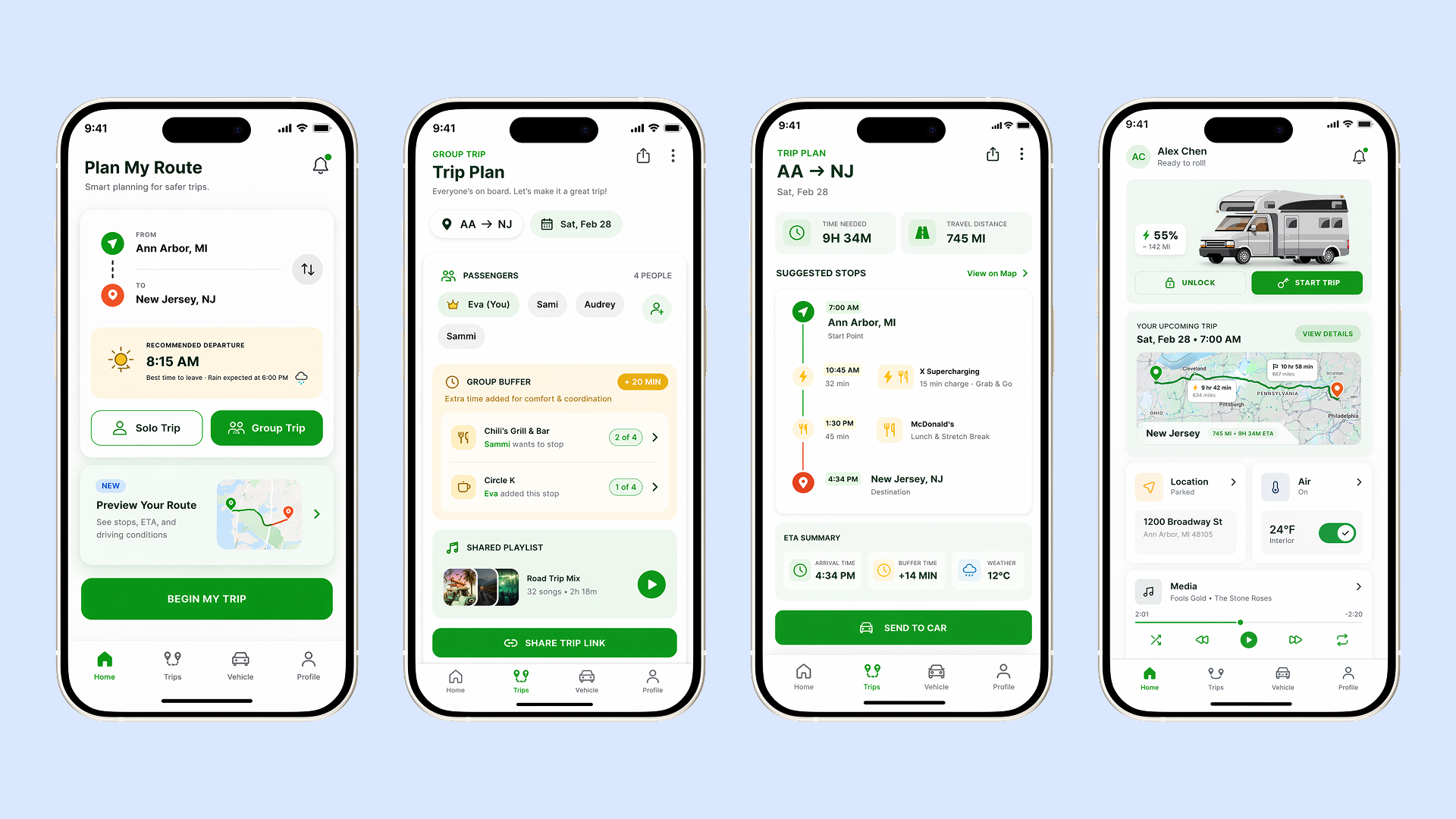
Designed responsive interfaces for both the in-vehicle dashboard and companion mobile application, enabling seamless interaction before and during trips.
Iteration
Refined navigation hierarchy, information density, and visual prioritization to ensure critical driving information remained accessible while minimizing distraction.
Results
Although this was a conceptual academic project, the proposed design identified measurable success metrics focused on both user behavior and business value. These included increasing engagement with safety alerts, improving onboarding completion, encouraging repeated use across multiple trips, and reducing perceived travel stress while increasing driver confidence.
Final Solution
Four capabilities make up the PathPal driving companion.
Smart Trip Planning
Drivers can create, organize, and manage road trips with automated recommendations for routes, rest stops, fuel, and food based on travel conditions.
Fatigue Awareness
The platform proactively recommends breaks based on trip duration and driving patterns, helping reduce fatigue and improve driver safety.
Collaborative Travel
Passengers can participate by suggesting destinations, coordinating stops, and sharing trip information, reducing the planning burden placed solely on the driver.
Driver-Centered Dashboard
A clean, glanceable interface prioritizes essential driving information while surfacing recommendations at appropriate moments to minimize distraction.
Reflection
What I Learned
Three lessons from designing a driver companion for long-distance travel.
Function Has to Be Weighed Against Cognitive Load
Automotive experiences require balancing functionality with minimal cognitive load, ensuring drivers receive useful information without increasing distraction.
Safety Means Anticipating, Not Reacting
Designing for safety means anticipating user needs before they become problems, rather than simply reacting to them.
One Ecosystem Beats Separate Apps
Integrating planning, navigation, and collaborative features into one ecosystem creates a more cohesive travel experience than relying on separate applications.